A strong cold similar to 2018, when a strong cold wave hit, begins on the 6th. The Meteorological Administration said on the 5th, “The temperature of the whole country is gradually lowering until the 8th, and a strong cold wave such as the lowest temperature in the morning of -17°C and the highest temperature in the daytime -10°C will come. , The cold will continue until mid-January.” From the night of the 5th, a cold wave warning was in effect in parts of the metropolitan area, Yeongseo, Gangwon, and Chungbuk, and a cold wave warning in other metropolitan areas, Chungcheong-Gangwon, and parts of Gyeongbuk.
Seoul morning on the 8th, the minimum temperature is -17 degrees Celsius
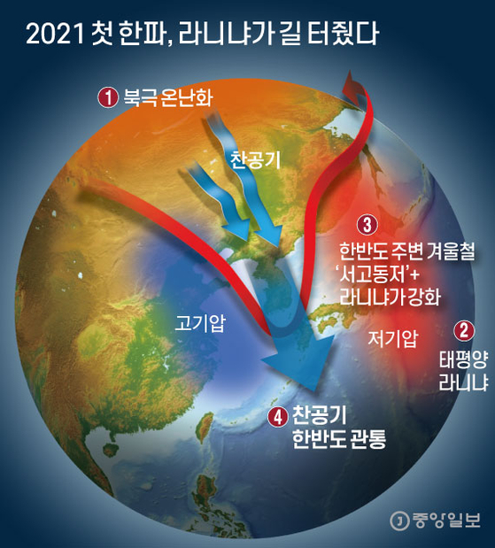
La Niña influences the Arctic cold wave
The cold is expected to continue until mid-January

The first cold wave in 2021, La Niña paved the way Graphic = Reporter Kim Joo-won [email protected]
The minimum temperature in the morning of Seoul on the 6th is 11 degrees below zero and 6 degrees below zero in Gwangju and Busan. As colder air comes down from the 7th, the minimum temperature on the morning of the 7th is -20°C to 5°C, including -14°C in Seoul, and the minimum temperature on the morning of the 8th is -23°C to 1°C. On the 7th, even in the daytime, the maximum is -12 degrees to -3 degrees, and the whole country cannot go beyond zero.
Forecast analyst Woo Jin-gyu of the Meteorological Administration said, “The cold air below -30 degrees Celsius stays in the air above Korea. “It will be very cold as it falls below -10 degrees Celsius,” he said. “The wind blows strongly, so the perceived temperature will be lower.”
This long and strong cold is a joint venture between the warmed Arctic and the Pacific Ocean, which has been cooled by the occurrence of La Niña. In winter,’low pressure’ in the eastern sea of the Korean peninsula and’high pressure’ in the western continent are established every year, creating an air pressure arrangement in the form of’seogodong bottom’. This year, the impact of La Niña, which occurred in the middle of the Pacific Ocean, strengthened each of the two barometers, resulting in a strong goal between them. As the high temperature of the Arctic continues throughout this winter, pressure valleys are strongly placed along the path of cold air that has been pushed down from the polar regions, creating a’high pass’ path through which cold air can penetrate the upper part of the Korean Peninsula.
“As the high temperature continues in the Arctic this winter, the Arctic sea ice is the third lowest in history, and the cold energy around the Arctic comes down to the mid-latitude, causing a cold wave.” As a result, the’seogodongjeo’ around Korea became stronger and the north wind became stronger.” An official from the Meteorological Administration said, “This year’s cold wave will be held in five fingers since 2000, and it will be a similar level of cold as in 2018.”
Reporter Kim Jeongyeon [email protected]
