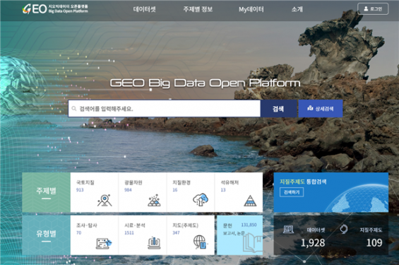
From the 6th of this month, the Korea Institute of Geoscience and Mineral Resources launched the’Geo Big Data Open Platform’, which provides a function that allows anyone to search and display geological resource data and papers free of charge in 3D maps. The picture is the main screen of the website. Provided by Korea Institute of Geoscience and Mineral Resources
An online open platform that anyone can download and use 133,000 domestic and foreign geological resource information for free has opened.
The Korea Institute of Geoscience and Mineral Resources announced on the 6th of this month that it will operate the’Geo Big Data Open Platform Service (https://data.kigam.re.kr)’ that integrates and discloses research data in the field of geological resources.
The Geovictator open platform provides a function that collects information that is difficult for individuals to find in one place and searches at once. It is possible to view data by research subject such as land geology and petroleum seabed. It is also possible to search 126,000 domestic and international geological resources related papers, 5500 research reports, 1500 geological samples, 350 maps, and 70 exploration data by type. Research data from government-funded research institutes and universities provided by the Korea Institute of Science and Technology Information (KISTI) national research data platform are also searched.
It also supports the function of making a geological map data such as the distribution map of Korean hot springs into a three-dimensional (3D) map to see at a glance. A geological map is a map that shows geological information such as the distribution of hot springs, rocks, and fault structures in a region, using various colors, shapes, and symbols. You can use’Geographic Subject System Integrated Search’ on the homepage of the Geo Big Data Open Platform. For example, if you search for’historical earthquakes’ and 2019 fault maps on the open platform and add them to the map, you can find out where and where earthquakes occurred in Korea and which faults occurred most in the past.

An integrated search screen for geological topics that allows you to visualize geological data and search for location information. Provided by Korea Institute of Geoscience and Mineral Resources
All geological samples such as rocks and drilling cores provided by the Geo Big Data open platform have international geological sample numbers listed to increase the reliability of the samples. The international geological sample number is a 9-digit code assigned to a sample containing geological information. Geological Research Institute is the first in Asia to be certified as an international geological sample number registration agency in 2015 and can assign an identification number.
To revitalize the geobig data open platform, Ji-yeon will hold the’Geological Resource Research Data Utilization Contest’ this year for those who use geological big data such as university students, graduate students, and professional researchers.
“Data and information in the non-face-to-face era is a key element in the value chain that is connected to We will do our best to provide it accurately.”
